Cooler Southeast Odds Contrast Western Warmth Through Early December
6-10 Day Temperatures
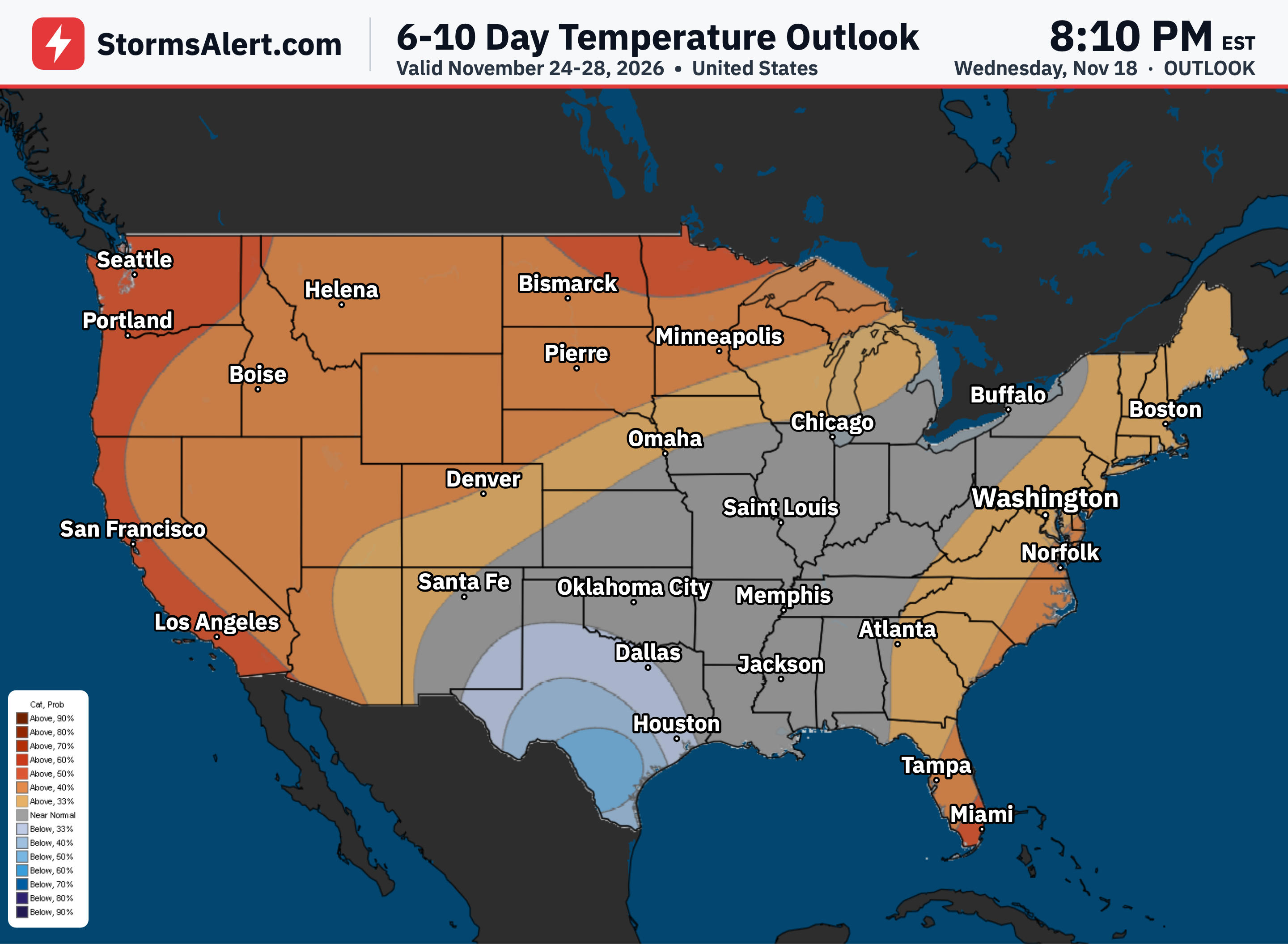
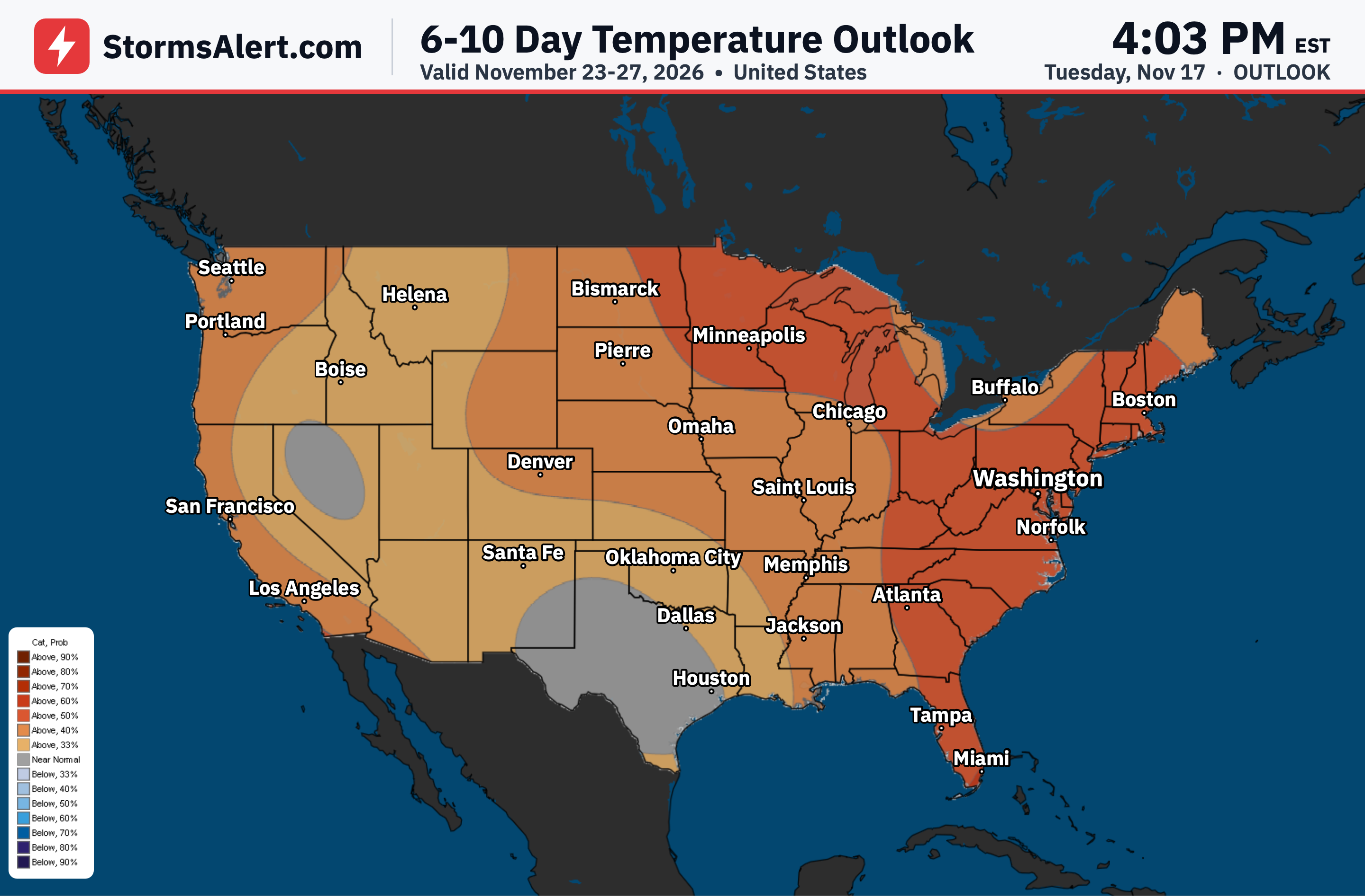
For November 25th to 29th, temperatures are favored to run above normal for the time of year from portions of the Great Lakes and northern Great Plains westward across the Rockies to the Pacific Coast. There is a better than 60 percent chance of warmer than normal weather along the immediate West Coast and over the extreme north-central United States. Cooler than normal air is expected near and just west of a trough over the Southeast, reaching as far north as the confluence of the Mississippi and Ohio Rivers, with odds for subnormal temperatures exceeding 50 percent from portions of the Lower Mississippi Valley westward through much of central and eastern Texas. Temperatures should average closer to normal along most of the East Coast and over the middle and upper Ohio Valley. Alaska is expected to average warmer than normal, especially in eastern portions, while cooler than normal mean temperatures are anticipated over central and northwestern Hawaii. Forecast confidence is above average for this period.
6-10 Day Precipitation
For November 25th to 29th, above normal precipitation is expected along the West Coast, with the best chances over 50 percent extending from central California northward to the Canadian border. Chances for above-normal precipitation also exceed 50 percent from the Florida Peninsula along the immediate Atlantic Coast from Georgia through the Carolinas. Subnormal precipitation is favored in and near southern Arizona, and from portions of the Middle Mississippi Valley northward through the northern Great Plains, Upper Mississippi Valley, and Upper Great Lakes. Farther north, above-normal precipitation is nominally favored over the southeastern Alaska Mainland and the Panhandle while drier than normal conditions are expected over western and northern parts of the Mainland. Subnormal rainfall is also anticipated over northwestern Hawaii. Forecast confidence remains above average for this period.
8-14 Day Temperatures
For November 27th to December 3rd, above normal temperatures are favored across a majority of the contiguous United States, with near- or below-normal temperature forecasts restricted to the southern Great Plains, Lower Mississippi Valley, and the Southeast. The best chances for abnormal warmth exceed 70 percent over the northernmost western Great Lakes and part of northern Minnesota. Chances for above-normal temperatures top 50 percent over the Pacific Coast States and the northern tier of the country from the Rockies through the Great Lakes. The forecast nominally favors subnormal mean temperatures from eastern Texas through the central Gulf Coast States and across southern Georgia. Abnormally warm conditions are expected to continue across Alaska, especially in southeastern sections, while temperatures across Hawaii are favored above normal on the Big Island, below normal in Kauai and Niihau, and near normal across the interior of the island chain. Forecast confidence is about average for this period.
8-14 Day Precipitation
For November 27th to December 3rd, wetter than normal weather is favored across the western contiguous United States. Above-normal precipitation is also favored from the southern Plains through the Tennessee and Lower Mississippi Valleys, the Gulf Coast Region, and much of the Eastern Seaboard. Chances for surplus precipitation exceed 40 percent west of the Rockies and near the Gulf and South Atlantic Coasts. Between these areas, from the Southwest through much of the Plains and most locations from the Ohio and Middle Mississippi River Valleys northward, near-normal amounts are favored, with the small exception of subnormal precipitation over the Upper Great Lakes. Across Alaska, wetter than normal conditions remain nominally favored in southeastern areas while the northern and western tiers of the Mainland are more likely to experience an unusually dry period. Subnormal precipitation is also favored across Hawaii. Forecast confidence is about average for this period.